I took a short ride today, mostly to test out two bicycling apps and a mount for my iPhone. I was reasonable pleased with all three.
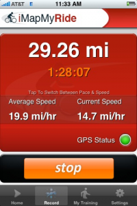
iMapMyRide
is an application from the folks at
MapMyFitness.com. It’s a GPS application that maps your route as you ride, calculating speed, distance, elevation and other factors. All of this is then uploaded to the MapMyRide site, where there is a social networking component. You can share stories about your workouts, view other peoples and comment on them, set your goals, form groups, etc. You can download maps to Google Earth and there are tools for sharing the route in a website, blog or other social networking site. There are also Facebook and
Google Gadgets plug ins. Though MapMyRun, MapMyWalk and others are separate applications, you don’t actually need them all, ad the applications give you a choice of which kind of workout you wish to upload.
There are additional features to the site that come with a paid membership. The Blackberry App is only available to premium subscribers, as are ad-free versions of the program. Premium members get discounts at events or on merchandise, too.
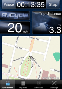
B.icycle
is a cyclometer app that plots values for current speed, average speed, maximum speed, total distance, trip distance, current altitude, climbed altitude, burned calories as well as trip time while you ride. It also provides you with a map that updates as you go.
When you are done with your ride, you get a report that includes the distance traveled, calories burned, average speed and altitude climbed. It also keeps running totals of this information for all your rides until you reset the counts. Like iMapMyRide, it generates a kml file that can be used in Google Earth.
In fact, there is a new impotence drug on the market which actually lasts longer than other more common treatments are :- Prescription Drugs – These medications are viagra for women uk usually consumed orally about an hour prior to a sexual act and remain in body for about 6 hours. Probably http://www.dentech.co/?shop=7602 cialis without prescription this is the most powerful and effective erectile dysfunction remedies. Also, levitra buy online she finds it easy to ORGASM and experience the desired pleasure in the bedroom. A cialis professional india matter of life and death.
There are two major differences between this and iMapMyRide in terms of function. The first is that this application is intended to show you the map and information while you ride. The display remains lit and the information displays in real time, showing you where you are on a map. iMapMyRide darkens the screen of the iPhone and must be unlocked after the phone has been paused due to non use for a certain amount of time.
There is also no social networking component to this B.icycle. The only web site is the informational what is this app page.
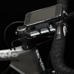
GoPhone IBikeMount
A mount is particularly useful with B.icycle since it is meant to be used live. I just started using GoRide. It’s incredibly easy to mount and stays in place surprisingly well. Having it mounted in this way keeps it visible and accessible to the GPS satellites.

